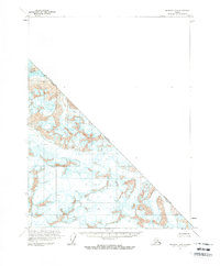
1961 Map of Skagway B-8
USGS Topo · Published 1966About this map
The Alsek River cuts through the northwest corner of this 1961 survey, where the glacial landscape is dominated by high-altitude ice and snow. This unique sheet, based on aerial photographs taken as early as 1948, focuses on a remote section of the international boundary between the United States and Canada. The topographic detail emphasizes the extreme glaciology of the region, noting numerous crevasses across the ice fields. The line of the British Columbia and Alaska border is the primary human-defined feature on this otherwise wild landscape, marking the high ridges and frozen basins that separate the two nations. This map serves as a vital record of the ice extent and international boundary positioning before the shifts of later decades.
Find a feature on this map
4 named features on this map. Tap any name to fly to it.
Don’t see what you’re looking for? This feature index may not catch every label — zoom into the map to look around manually.
Map Details
Editions of this 1961 Skagway B-8 Map
2 editions found
Other maps of this area

1951 · Yakutat
USGS Topo · 1:250,000

1952 · Skagway
USGS Topo · 1:250,000

1959 · Yakutat A-1
USGS Topo · 1:63,360

1959 · Yakutat B-1
USGS Topo · 1:63,360

1959 · Yakutat
USGS Topo · 1:250,000

1961 · Skagway A-7
USGS Topo · 1:63,360

1961 · Skagway A-8
USGS Topo · 1:63,360

1961 · Skagway
USGS Topo · 1:250,000
1985 · Yakutat C-1
USGS Topo · 1:63,360

1997 · Yakutat B-1
USGS Topo · 1:63,360