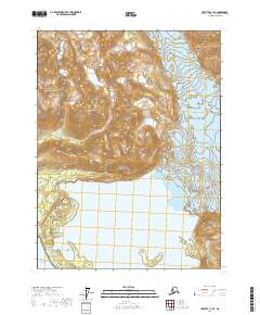
2017 Map of Yakutat A-1 SE
USGS Topo · Published 2017About this map
The Glacier Bay National Park and Glacier Bay National Preserve meet at a dynamic boundary where ice and water define the landscape. The northern reaches are dominated by the Deception Hills, a complex of elevations that channel the Doame River and its tributary, the S-Fork Doame River. This hydrologic system feeds into Upper Doame Lake before descending toward the coast. To the east, the massive Grand Plateau Glacier pushes toward the sea, illustrating the glacial processes that continue to shape this corner of the state. The map transitions from these high peaks and ice fields to the open waters of the Gulf of Alaska, capturing a wilderness area where natural barriers have dictated the absence of roads and permanent settlements.
Find a feature on this map
14 named features on this map. Tap any name to fly to it.
Don’t see what you’re looking for? This feature index may not catch every label — zoom into the map to look around manually.
Map Details
Editions of this 2017 Yakutat A-1 SE Map
This is the sole edition of this map. No revisions or reprints were ever made.
Other maps of this area

1951 · Yakutat
USGS Topo · 1:250,000

1951 · Mt Fairweather
USGS Topo · 1:250,000

1952 · Skagway
USGS Topo · 1:250,000

1959 · Yakutat A-1
USGS Topo · 1:63,360

1959 · Yakutat
USGS Topo · 1:250,000
1961 · Mount Fairweather D-7
USGS Topo · 1:63,360

1961 · Mount Fairweather D-6
USGS Topo · 1:63,360

1961 · Skagway A-8
USGS Topo · 1:63,360

1961 · Mt Fairweather
USGS Topo · 1:250,000

1961 · Skagway
USGS Topo · 1:250,000