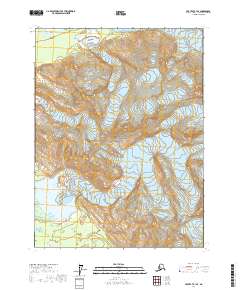
2017 Map of Yakutat B-1 SE
USGS Topo · Published 2017About this map
Glacier Bay National Park dominates this 2017 survey of the Alaskan coast near Yakutat. The terrain is characterized by massive ice fields and steep elevation changes, with the Alsek Glacier moving through the southeastern corner of the quadrangle. This map documents a dynamic glacial landscape where the ice-water interface and surrounding wilderness remain largely untouched by permanent human settlement. While the sheet includes township and range designations such as t30s r43e and t29s r44e, there are no roads or buildings, emphasizing the remote nature of this protected environment. Researchers can observe the contours and hydrological patterns that define the modern extent of the glacier as it existed during the early 21st century.
Find a feature on this map
8 named features on this map. Tap any name to fly to it.
Don’t see what you’re looking for? This feature index may not catch every label — zoom into the map to look around manually.
Map Details
Editions of this 2017 Yakutat B-1 SE Map
This is the sole edition of this map. No revisions or reprints were ever made.
Other maps of this area

1951 · Yakutat
USGS Topo · 1:250,000

1952 · Skagway
USGS Topo · 1:250,000

1959 · Yakutat A-1
USGS Topo · 1:63,360

1959 · Yakutat B-1
USGS Topo · 1:63,360

1959 · Yakutat
USGS Topo · 1:250,000
1961 · Skagway B-8
USGS Topo · 1:63,360

1961 · Skagway A-8
USGS Topo · 1:63,360

1961 · Skagway
USGS Topo · 1:250,000

1997 · Yakutat B-1
USGS Topo · 1:63,360
2017 · Yakutat A-1 NW
USGS Topo · 1:25,000