
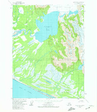
1959 Map of Yakutat B-3
USGS Topo · Published 1963About this map
The Brabazon Range dominates the eastern portion of this coastal landscape, where the Yakutat Glacier and Chamberlain Glacier feed into a complex network of glacial meltwater. The transition from the high peaks to the Gulf of Alaska is marked by the expansive Harlequin Lake, which drains through the strikingly named Dangerous River. This 1959 survey reveals the intricate hydrography of the Tongass National Forest, showing a labyrinth of braided channels including the Italio River and Akwe River as they snake through lowland flats toward the sea.
Find a feature on this map
18 named features on this map. Tap any name to fly to it.
Don’t see what you’re looking for? This feature index may not catch every label — zoom into the map to look around manually.
Map Details
Editions of this 1959 Yakutat B-3 Map
2 editions found
Other maps of this area

1951 · Yakutat
USGS Topo · 1:250,000

1959 · Yakutat C-3
USGS Topo · 1:63,360

1959 · Yakutat A-2
USGS Topo · 1:63,360
1959 · Yakutat A-3
USGS Topo · 1:63,360

1959 · Yakutat C-4
USGS Topo · 1:63,360

1959 · Yakutat B-2
USGS Topo · 1:63,360

1959 · Yakutat B-4
USGS Topo · 1:63,360

1959 · Yakutat
USGS Topo · 1:250,000

1985 · Yakutat C-2
USGS Topo · 1:63,360
1987 · Yakutat C-4 SE
USGS Topo · 1:25,000