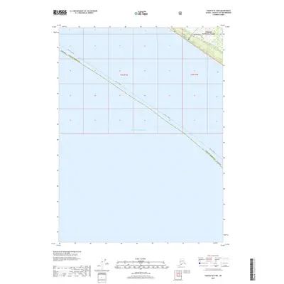
2017 Map of Yakutat B-5 NW
USGS Topo · Published 2017About this map
Cannon Beach and the edge of the Tongass National Forest meet the vast waters of the Gulf of Alaska in this remote coastal survey. The map records a distinct intersection of wilderness and localized activity near the mouth of Taiya Cr, where the northernmost corner of the map reveals a small cluster of named landmarks. Most notably, a Pet Cemetery is located along Beach Road, a site that offers a rare personal touch in an otherwise expansive and largely undeveloped landscape. The inclusion of the Dry Bay Canoe Trail highlights the traditional and recreational modes of travel that define this region, where land and water transit are deeply intertwined. This survey also serves to document the precise administrative boundary line between the Alaska Yakutat Borough and Yakutat - Juneau.
Find a feature on this map
12 named features on this map. Tap any name to fly to it.
Don’t see what you’re looking for? This feature index may not catch every label — zoom into the map to look around manually.
Map Details
Editions of this 2017 Yakutat B-5 NW Map
This is the sole edition of this map. No revisions or reprints were ever made.
Other maps of this area

1951 · Yakutat
USGS Topo · 1:250,000

1959 · Yakutat B-5
USGS Topo · 1:63,360

1959 · Yakutat C-5
USGS Topo · 1:63,360

1959 · Yakutat
USGS Topo · 1:250,000
1985 · Yakutat C-6
USGS Topo · 1:63,360
1987 · Yakutat C-5 SE
USGS Topo · 1:25,000
1987 · Yakutat B-5 NE
USGS Topo · 1:25,000
1987 · Yakutat C-5 SW
USGS Topo · 1:25,000
1996 · Yakutat C-5
USGS Topo · 1:63,360
2017 · Yakutat B-5 NE
USGS Topo · 1:25,000