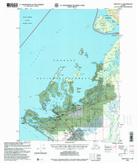
1996 Map of Yakutat C-5
USGS Topo · Published 2000About this map
Yakutat sits at the nexus of a complex glacial landscape where the Gulf of Alaska meets the protected waters of Yakutat Bay. This late-twentieth-century survey documents a coastal environment defined by transition, from the industrial Log Transfer Facility and Log Storage Yard at Sawmill Cove to the aviation infrastructure of the Yakutat Airport and nearby Vortac Station (FAA). The mapping of Phipps Peninsula and Khantaak Island reveals a shoreline heavily influenced by maritime activity, marked by the Ocean Cape Light and several small cabins along the inlets. Inland, the Dangerous River Road pushes eastward toward the Situk River, a vital waterway cutting through the heavy timber of the Tongass National Forest. Researchers will find significant local detail, including a Cem near Graveyard Cove and the positioning of Communication Towers and a Microwave Tower serving this isolated coastal outpost.
Find a feature on this map
78 named features on this map. Tap any name to fly to it.
Don’t see what you’re looking for? This feature index may not catch every label — zoom into the map to look around manually.
Map Details
Editions of this 1996 Yakutat C-5 Map
This is the sole edition of this map. No revisions or reprints were ever made.
Other maps of this area

1951 · Yakutat
USGS Topo · 1:250,000

1959 · Yakutat B-5
USGS Topo · 1:63,360

1959 · Yakutat C-5
USGS Topo · 1:63,360

1959 · Yakutat D-4
USGS Topo · 1:63,360

1959 · Yakutat C-4
USGS Topo · 1:63,360

1959 · Yakutat B-4
USGS Topo · 1:63,360

1959 · Yakutat D-5
USGS Topo · 1:63,360

1959 · Yakutat
USGS Topo · 1:250,000
1985 · Yakutat D-6
USGS Topo · 1:63,360
1985 · Yakutat C-6
USGS Topo · 1:63,360