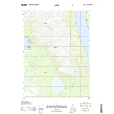
2017 Map of Yakutat C-4 NW
USGS Topo · Published 2017About this map
Yakutat serves as a small anchor point in this coastal Alaskan landscape, where the edges of the Tongass National Forest meet the waters of the Russell Fiord. The terrain is defined by dramatic elevation changes, rising from the shoreline at Eleanor Cove and Chicago Harbor to the heights of Mt Tebenkof and Mt Mallott. To the north, the Rasmuson Glacier dominates the upper reaches, illustrating the glacial forces that have carved this portion of the Yakutat City and Borough. In the southern half, the landscape transitions into a complex system of wetlands and freshwater bodies, including Situk Lake and Lake Redfield. The Situk River flows through this area, while a singular gated road, W Gate, provides one of the few named land-based access points in an otherwise maritime and wilderness-focused region. This map highlights the precarious balance between sea, ice, and temperate rainforest at a specific moment in the early twenty-first century.
Find a feature on this map
17 named features on this map. Tap any name to fly to it.
Don’t see what you’re looking for? This feature index may not catch every label — zoom into the map to look around manually.
Map Details
Editions of this 2017 Yakutat C-4 NW Map
This is the sole edition of this map. No revisions or reprints were ever made.
Other maps of this area

1951 · Yakutat
USGS Topo · 1:250,000

1959 · Yakutat C-5
USGS Topo · 1:63,360

1959 · Yakutat D-4
USGS Topo · 1:63,360

1959 · Yakutat C-4
USGS Topo · 1:63,360

1959 · Yakutat D-5
USGS Topo · 1:63,360

1959 · Yakutat
USGS Topo · 1:250,000

1987 · Yakutat C-4 SW
USGS Topo · 1:25,000
1987 · Yakutat C-4 SE
USGS Topo · 1:25,000
1987 · Yakutat C-5 SE
USGS Topo · 1:25,000
1996 · Yakutat C-5
USGS Topo · 1:63,360