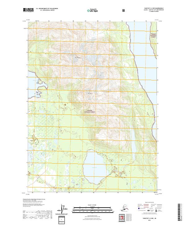
2021 Map of Yakutat C-4 NW
USGS Topo · Published 2021About this map
Saint Elias Mountains define the northern reaches of this coastal landscape within the Tongass National Forest. The map documents a transition from the high peaks of Mt Tebenkof and Mt Mallott down to the intricate shoreline of Eleanor Cove and Chicago Harbor. This coastal interface is marked by tidal features like New Reefs and the sheltered waters of Ensenada de Esperanza. Inland, the drainage systems of Situk Lake and the meandering Situk River dominate the southern lowlands, providing a clear view of the hydrological patterns of the Yakutat City and Borough. Connectivity through this wilderness is traced by the Situk Lake Trl and Mountain Lake Trl, while the western boundary is noted by the West Gate label. These trails and water bodies, including Lake Redfield, illustrate the geography of a region shaped by both glacial runoff and the Pacific tide.
Find a feature on this map
19 named features on this map. Tap any name to fly to it.
Don’t see what you’re looking for? This feature index may not catch every label — zoom into the map to look around manually.
Map Details
Editions of this 2021 Yakutat C-4 NW Map
This is the sole edition of this map. No revisions or reprints were ever made.
Other maps of this area

1951 · Yakutat
USGS Topo · 1:250,000

1959 · Yakutat C-5
USGS Topo · 1:63,360

1959 · Yakutat D-4
USGS Topo · 1:63,360

1959 · Yakutat C-4
USGS Topo · 1:63,360

1959 · Yakutat D-5
USGS Topo · 1:63,360

1959 · Yakutat
USGS Topo · 1:250,000

1987 · Yakutat C-4 SW
USGS Topo · 1:25,000
1987 · Yakutat C-4 SE
USGS Topo · 1:25,000
1987 · Yakutat C-5 SE
USGS Topo · 1:25,000
1996 · Yakutat C-5
USGS Topo · 1:63,360