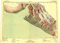
1951 Map of Yakutat
USGS Topo · Published 1952About this map
Yakutat serves as the primary coastal hub on this mid-century survey, situated on the Phipps Peninsula between the Gulf of Alaska and the island-dotted waters of Yakutat Bay. The 1951 compilation highlights the strategic importance of the Military Airport located just south of the settlement, while the remote coastal outpost of Black Sand sits near the mouth of the Situk River.
Find a feature on this map
81 named features on this map. Tap any name to fly to it.
Don’t see what you’re looking for? This feature index may not catch every label — zoom into the map to look around manually.
Map Details
Editions of this 1951 Yakutat Map
4 editions found
Other maps of this area

1950 · Bering Glacier
USGS Topo · 1:250,000

1950 · Icy Bay
USGS Topo · 1:250,000

1951 · Icy Bay
USGS Topo · 1:250,000

1951 · Bering Glacier
USGS Topo · 1:250,000

1951 · Yakutat
USGS Topo · 1:250,000

1951 · Mt Saint Elias
USGS Topo · 1:250,000

1951 · Mt Fairweather
USGS Topo · 1:250,000

1952 · Skagway
USGS Topo · 1:250,000

1959 · Yakutat A-1
USGS Topo · 1:63,360

1959 · Yakutat C-3
USGS Topo · 1:63,360