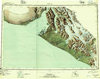
1951 Map of Yakutat
USGS Topo · Published 1954About this map
The coastal village of Yakutat serves as the primary outpost in this 1951 provisional survey, situated on the edge of the expansive Yakutat Bay. The landscape is dominated by the massive Malaspina Glacier to the northwest and the towering Saint Elias Mountains along the Canadian border. This map captures a post-war moment in the region's geography, showing the Military Airport near the settlement and the wild, unpeopled reaches of the Tongass National Forest. Inland, the complex drainage systems of the Alsek River and Dangerous River carve through glacial sediment toward the Gulf of Alaska. The presence of numerous named peaks like Mt Aylesworth and Mt Armour along the international boundary reflects the era's focus on defining the rugged Alaskan frontier. Significant water bodies such as Russell Fiord and Harlequin Lake highlight the dynamic nature of this glacial coastline before more modern mapping was completed.
Find a feature on this map
95 named features on this map. Tap any name to fly to it.
Don’t see what you’re looking for? This feature index may not catch every label — zoom into the map to look around manually.
Map Details
Editions of this 1951 Yakutat Map
4 editions found
Other maps of this area

1950 · Bering Glacier
USGS Topo · 1:250,000

1950 · Icy Bay
USGS Topo · 1:250,000

1951 · Icy Bay
USGS Topo · 1:250,000

1951 · Bering Glacier
USGS Topo · 1:250,000

1951 · Yakutat
USGS Topo · 1:250,000

1951 · Mt Saint Elias
USGS Topo · 1:250,000

1951 · Mt Fairweather
USGS Topo · 1:250,000

1952 · Skagway
USGS Topo · 1:250,000

1959 · Yakutat A-1
USGS Topo · 1:63,360

1959 · Yakutat C-3
USGS Topo · 1:63,360