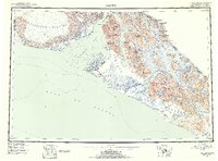
1951 Map of Yakutat
USGS Topo · Published 1954About this map
The coastal settlement of Yakutat sits at the edge of the Tongass National Forest, serving as a vital link between the Gulf of Alaska and the glacial interior. This 1951 survey, compiled from Trimetrogon photography and original 1906–1908 international boundary records, reveals a landscape dominated by the massive Malaspina Glacier and the towering peaks of the Saint Elias Mountains. The map documents the strategic importance of the area during the early Cold War era, featuring a Military Airport just south of the main village.
Find a feature on this map
89 named features on this map. Tap any name to fly to it.
Don’t see what you’re looking for? This feature index may not catch every label — zoom into the map to look around manually.
Map Details
Editions of this 1951 Yakutat Map
4 editions found
Other maps of this area

1950 · Bering Glacier
USGS Topo · 1:250,000

1950 · Icy Bay
USGS Topo · 1:250,000

1951 · Icy Bay
USGS Topo · 1:250,000

1951 · Bering Glacier
USGS Topo · 1:250,000

1951 · Yakutat
USGS Topo · 1:250,000

1951 · Mt Saint Elias
USGS Topo · 1:250,000

1951 · Mt Fairweather
USGS Topo · 1:250,000

1952 · Skagway
USGS Topo · 1:250,000

1959 · Yakutat A-1
USGS Topo · 1:63,360

1959 · Yakutat C-3
USGS Topo · 1:63,360