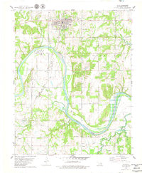
1978 Map of Yale
USGS Topo · Published 1979About this map
Oil fields and storage infrastructure dominate the landscape around Yale, a community shaped by the petroleum industry of north-central Oklahoma. In the late 1970s, the town's industrial footprint is evidenced by a massive Tank Farm and the Cartoco facility, while local recreation is found at Jim Thorpe Park. The winding Cimarron River carves through the terrain, with its southeastern reaches beginning to form the backwaters of Keystone Lake. Transportation patterns are shifting during this era; while the Atchison Topeka and Santa Fe Missouri-Kansas-Texas line still cuts through the central valley, an Old Railroad Grade near Schlegel points to earlier rail corridors that had already been decommissioned. Rural life is anchored by landmarks like Deep Rock Sch, Underwood Cem, and the small settlement of Norfolk.
Find a feature on this map
29 named features on this map. Tap any name to fly to it.
Don’t see what you’re looking for? This feature index may not catch every label — zoom into the map to look around manually.
Map Details
Editions of this 1978 Yale Map
This is the sole edition of this map. No revisions or reprints were ever made.
Other maps of this area

1908 · Agra
USGS Topo · 1:62,500

1929 · Yale
USGS Topo · 1:62,500

1929 · Ripley
USGS Topo · 1:62,500

1931 · Drumright
USGS Topo · 1:62,500

1932 · Yale
USGS Topo · 1:62,500

1932 · Ripley
USGS Topo · 1:62,500

1954 · Oklahoma City
USGS Topo · 1:250,000

1955 · Enid
USGS Topo · 1:250,000

1957 · Oklahoma City
USGS Topo · 1:250,000

1958 · Enid
USGS Topo · 1:250,000