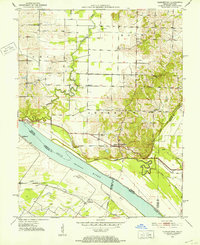
1951 Map of Yankeetown
USGS Topo · Published 1952About this map
The Ohio River defines the southern boundary of this early 1950s survey, where the borders of Indiana and Kentucky meet amidst a landscape of river-bottom drainage and uplands. Settlement is concentrated in small rural clusters such as Yankeetown, Pelzer, and Dayville, often centered around community landmarks like St Rupert Ch and Bethany Ch. The map captures an era of agricultural management and early industrial extraction, evidenced by the extensive network of drainage features including George Ditch, Horsman Ditch, and Willow Pond Ditch, which channel water toward the Little Pigeon Creek. Scattered Oil Wells and the small settlement of Carlinburg south of the river indicate the burgeoning resource economy of the period. Genealogists will find value in the placement of Vanada Cem and several unnamed cemeteries located near historic churches.
Find a feature on this map
32 named features on this map. Tap any name to fly to it.
Don’t see what you’re looking for? This feature index may not catch every label — zoom into the map to look around manually.
Map Details
Editions of this 1951 Yankeetown Map
2 editions found
Other maps of this area

1900 · De Gonia Springs
USGS Topo · 1:62,500

1901 · Owensboro
USGS Topo · 1:62,500

1902 · Ditney
USGS Topo · 1:125,000

1902 · Degonia Springs
USGS Topo · 1:62,500

1902 · Boonville
USGS Topo · 1:62,500

1905 · Newburg
USGS Topo · 1:62,500

1951 · Yankeetown
USGS Topo · 1:24,000

1951 · Spottsville
USGS Topo · 1:24,000

1952 · Owensboro West
USGS Topo · 1:24,000

1952 · Newburgh
USGS Topo · 1:24,000