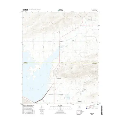
2016 Map of Yanush
USGS Topo · Published 2016About this map
The boundary between Latimer Co and Pushmataha Co bisects this Oklahoma landscape, which is defined by the massive footprint of Sardis Lake to the west and the Kiamichi River valley terrain to the southeast. The settlement of Yanush serves as a central point along the highway, surrounded by family-named landmarks and historical burial grounds such as Hokit Cem and Cupco Cem. To the south, the community of Tuskahoma sits near the base of the winding Co Rd 4355 and Co Rd 4340, which navigate the wetlands around Lake Nanih Waiya. Numerous creeks, including Buffalo Creek and Cedar Cr, drain the elevated ridges into the larger reservoirs. This survey provides a clear view of the rural road network, from established routes like Anderson Creek Rd to smaller traces like Snakie Hill and Mcguire-Lennon Rd.
Find a feature on this map
45 named features on this map. Tap any name to fly to it.
Don’t see what you’re looking for? This feature index may not catch every label — zoom into the map to look around manually.
Map Details
Editions of this 2016 Yanush Map
This is the sole edition of this map. No revisions or reprints were ever made.
Other maps of this area

1901 · Tuskahoma
USGS Topo · 1:125,000

1908 · Tuskahoma
USGS Topo · 1:125,000

1909 · Tuskahoma
USGS Topo · 1:125,000

1940 · Red Oak
USGS Topo · 1:62,500

1943 · Red Oak
USGS Topo · 1:62,500

1950 · Mcalester
USGS Topo · 1:250,000

1962 · McAlester
USGS Topo · 1:250,000

1965 · McAlester
USGS Topo · 1:250,000

1971 · Yanush
USGS Topo · 1:24,000

1971 · Kiamichi
USGS Topo · 1:24,000