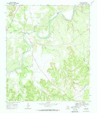
1968 Map of Yates
USGS Topo · Published 1971About this map
The Llano River carves a winding path through this portion of the Texas Hill Country, anchoring the small settlement at Yates. This 1968 field survey reveals a landscape where water determines the pattern of life, with major tributaries like Red Creek and Salty Creek cutting through the terrain. Evidence of local community roots is found at the Red Creek Cem north of the river and Ivy Chapel tucked near the confluence of Cedar Creek. To the south, the topography rises sharply into the Blue Mountains, where the elevation changes become more dramatic. The map captures a moment when traditional ranching and rural infrastructure coexisted with modern energy developments, indicated by a series of pipelines crossing the northern territory. Local industry is represented by a Gravel Pit near the river, illustrating the modest extraction activities common to the area during the late 1960s.
Find a feature on this map
16 named features on this map. Tap any name to fly to it.
Don’t see what you’re looking for? This feature index may not catch every label — zoom into the map to look around manually.
Map Details
Editions of this 1968 Yates Map
2 editions found
Other maps of this area

1887 · Mason
USGS Topo · 1:125,000

1894 · Mason
USGS Topo · 1:125,000

1894 · Kerrville
USGS Topo · 1:125,000

1954 · Llano
USGS Topo · 1:250,000

1955 · Llano
USGS Topo · 1:250,000

1956 · Llano
USGS Topo · 1:250,000

1968 · Monument Mountain
USGS Topo · 1:24,000

1968 · Sheep Run Creek
USGS Topo · 1:24,000

1968 · London
USGS Topo · 1:24,000

1968 · Yates
USGS Topo · 1:24,000