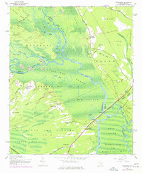
1943 Map of Yauhannah
USGS Topo · Published 1977About this map
Pee Dee River and Little Pee Dee River converge in a complex network of wetlands and islands at the junction of Georgetown, Marion, and Horry counties. The landscape is defined by vast designated areas like Carvers Bay No 6 and Pee Dee and Choppee No 5, where the river creates natural boundaries and landmarks such as Big Island and Hell Gate. This mid-century survey reveals a rural society centered on river crossings and timber, evidenced by the Wooden Trestle and the Old Tram Road cutting through the Pee Dee Swamp.
Find a feature on this map
60 named features on this map. Tap any name to fly to it.
Don’t see what you’re looking for? This feature index may not catch every label — zoom into the map to look around manually.
Map Details
Editions of this 1943 Yauhannah Map
4 editions found
Other maps of this area

1943 · Yauhannah
USGS Topo · 1:24,000

1943 · Bucksville
USGS Topo · 1:24,000

1943 · Carvers Bay
USGS Topo · 1:24,000

1943 · Brookgreen
USGS Topo · 1:24,000

1943 · Plantersville
USGS Topo · 1:24,000

1943 · Dongola
USGS Topo · 1:24,000

1943 · Conway
USGS Topo · 1:24,000

1943 · Outland
USGS Topo · 1:24,000

1944 · Outland
USGS Topo · 1:31,680

1946 · Johnsonville
USGS Topo · 1:62,500