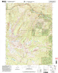
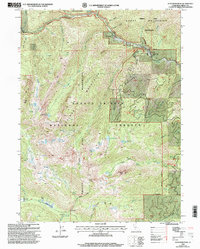
1998 Map of Ycatapom Peak
USGS Topo · Published 2003About this map
Alps Mountains dominate this high-elevation landscape within the Trinity Alps Wilderness, where glacial basins have formed a dense network of alpine waters including Sugar Pine Lake, Tangle Blue Lake, and Lilypad Lake. The terrain is defined by steep drainages like Benson Gulch and Slide Gulch that feed into the Coffee Creek system. While primarily a protected wilderness area, the map preserves evidence of earlier human activity and resource extraction, notably at the Lady Slipper Mine near the northern boundary.
Find a feature on this map
52 named features on this map. Tap any name to fly to it.
Don’t see what you’re looking for? This feature index may not catch every label — zoom into the map to look around manually.
Map Details
Editions of this 1998 Ycatapom Peak Map
2 editions found
Other maps of this area

1886 · Shasta
USGS Topo · 1:250,000

1890 · Red Bluff
USGS Topo · 1:250,000

1894 · Red Bluff
USGS Topo · 1:250,000

1894 · Shasta
USGS Topo · 1:250,000

1913 · Weaverville
USGS Topo · 1:125,000

1923 · Sawyers Bar
USGS Topo · 1:125,000

1931 · Etna
USGS Topo · 1:96,000

1934 · Etna
USGS Topo · 1:125,000

1948 · Weed
USGS Topo · 1:250,000

1950 · Weed
USGS Topo · 1:250,000