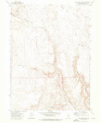
1972 Map of Yellow Hills West
USGS Topo · Published 1976About this map
High Rock Canyon dominates this portion of the northwestern Nevada desert, carving a deep path through the high plateau. In the early 1970s, this landscape remained largely defined by its isolation and its connection to the region's ranching heritage. Local landmarks like Stevens Camp and Bernards Corrals indicate the scattered presence of human activity in an area otherwise shaped by geological features. Named camps and homestead sites such as Van Riper Place and Bernard Place are linked by a network of unimproved tracks and a primitive Jeep Trail, illustrating the rugged accessibility of the terrain. The map details a complex drainage system including Wall Canyon, Pole Canyon, and Hanging Rock Creek, all descending from the volcanic heights of the Yellow Hills. These drainages and intermittent Springs provide the essential water sources that supported the seasonal livestock operations and camps found throughout this arid corner of Washoe County.
Find a feature on this map
16 named features on this map. Tap any name to fly to it.
Don’t see what you’re looking for? This feature index may not catch every label — zoom into the map to look around manually.
Map Details
Editions of this 1972 Yellow Hills West Map
3 editions found
Other maps of this area

1889 · Long Valley
USGS Topo · 1:250,000

1954 · Vya
USGS Topo · 1:250,000

1958 · Vya
USGS Topo · 1:250,000

1962 · Vya
USGS Topo · 1:250,000

1966 · Nut Mountain
USGS Topo · 1:24,000

1966 · Badger Mtn SE
USGS Topo · 1:24,000

1966 · Massacre Creek
USGS Topo · 1:24,000

1972 · Mahogany Mtn
USGS Topo · 1:24,000

1972 · High Rock Lake
USGS Topo · 1:24,000
1972 · Yellow Hills East
USGS Topo · 1:24,000