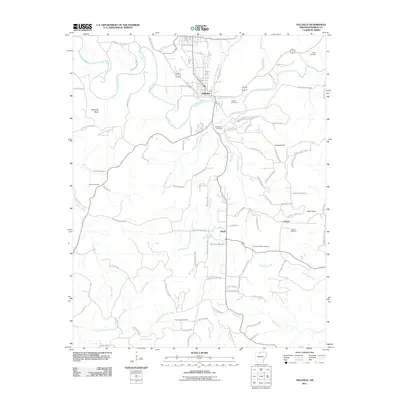
2011 Map of Yellville
USGS Topo · Published 2011About this map
Crooked Creek snakes across this Ozark landscape, providing the primary drainage for the settlement of Yellville. The town serves as a central hub, with a network of local roads like Marion County 4003 and Marion County 6014 radiating outward toward the smaller communities of Ralph and Cowan. This 2011 survey reveals a landscape where the upland terrain is marked by distinctive landmarks such as Standing Rock and Bald Jesse, while the creek bottoms accommodate several family and community burial grounds, including Wickersham Cemetery and Nanny Cemetery. To the south, the terrain becomes more isolated near the Freck Lookout Tower, overlooking the headwaters of Rush Creek and Nellon Creek. The distribution of these cemeteries and isolated homesteads along the hollows reflects a long-standing settlement pattern defined by the rugged topography of northern Arkansas.
Find a feature on this map
91 named features on this map. Tap any name to fly to it.
Don’t see what you’re looking for? This feature index may not catch every label — zoom into the map to look around manually.
Map Details
Editions of this 2011 Yellville Map
This is the sole edition of this map. No revisions or reprints were ever made.
Other maps of this area

1893 · Yellville
USGS Topo · 1:125,000

1903 · Yellville
USGS Topo · 1:125,000

1905 · Yellville
USGS Topo · 1:125,000

1929 · Yellville
USGS Topo · 1:125,000

1945 · Harrison
USGS Topo · 1:250,000

1949 · Harrison
USGS Topo · 1:250,000

1954 · Harrison
USGS Topo · 1:250,000

1958 · Harrison
USGS Topo · 1:250,000

1964 · Harrison
USGS Topo · 1:250,000
1966 · Cozahome
USGS Topo · 1:24,000