
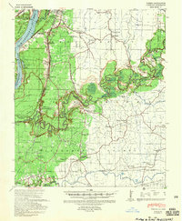
1939 Map of Yokena
USGS Topo · Published 1942About this map
The Mississippi River and Big Black River dictate the geography of this 1930s landscape, which spans the boundary between Warren and Claiborne counties. The map captures a period of significant river engineering, specifically noting the Diamond Cut-off 1933 and numerous revetments along Newtown Bend. Inland, the settlement of Rocky Springs stands as a focal point among a network of rural schoolhouses and churches that served the agricultural community, including the Hardscrabble Sch and Campbell Chapel.
Find a feature on this map
73 named features on this map. Tap any name to fly to it.
Don’t see what you’re looking for? This feature index may not catch every label — zoom into the map to look around manually.
Map Details
Editions of this 1939 Yokena Map
2 editions found
Other maps of this area

1909 · Mound
USGS Topo · 1:24,000

1910 · Mound
USGS Topo · 1:31,680

1918 · Vicksburg
USGS Topo · 1:62,500

1938 · Edwards
USGS Topo · 1:62,500

1939 · Talla Bena
USGS Topo · 1:62,500

1939 · Lorman
USGS Topo · 1:62,500

1941 · Vicksburg
USGS Topo · 1:62,500

1953 · Natchez
USGS Topo · 1:250,000

1955 · Jackson
USGS Topo · 1:250,000

1956 · Natchez
USGS Topo · 1:250,000