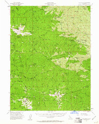
1954 Map of Yolla Bolly
USGS Topo · Published 1961About this map
The North Yolla Bolly Mts and their southern counterparts anchor this high-elevation wilderness where the borders of Trinity, Tehama, Mendocino, and Glenn counties converge. This 1954 survey by the Forest Service documents a landscape of remote camps and administrative outposts scattered across deep ridges and glades. Settlement is restricted to seasonal or specialized sites such as Weston Ranch and Johnson Hdqrs, while the Saddle Camp Guard Sta and various lookout points like Tomhead Mtn provide the only permanent infrastructure. The map reveals an intricate network of early trails, including the Humboldt Trail and N Yolla Bolly Trail, which served as the primary routes through the Yolla Bolly-Middle Eel Wilderness Area. For those tracing local history, the specific naming of remote glades like Murphy Glades and Appletree Glade provides a look into the grazing and forestry patterns of the mid-20th century, before more modern access reached these remote drainages.
Find a feature on this map
125 named features on this map. Tap any name to fly to it.
Don’t see what you’re looking for? This feature index may not catch every label — zoom into the map to look around manually.
Map Details
Editions of this 1954 Yolla Bolly Map
4 editions found

Other maps of this area

1890 · Red Bluff
USGS Topo · 1:250,000

1894 · Red Bluff
USGS Topo · 1:250,000

1926 · Covelo
USGS Topo · 1:62,500

1931 · Hoaglin
USGS Topo · 1:96,000

1935 · Hoaglin
USGS Topo · 1:125,000

1949 · Colyear Springs
USGS Topo · 1:62,500

1951 · Chanchelulla Peak
USGS Topo · 1:62,500

1952 · Paskenta
USGS Topo · 1:62,500

1952 · Ono
USGS Topo · 1:62,500

1952 · Covelo
USGS Topo · 1:62,500