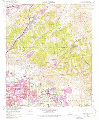
1964 Map of Yorba Linda
USGS Topo · Published 1975About this map
Urban expansion and industrial development define this region during the mid-1960s and early 1970s, as shown by the extensive purple tinting over Yorba Linda, Placentia, and Fullerton. The map documents a landscape in transition, where residential blocks and golf courses like the Alta Vista Golf Club meet the working infrastructure of the Oil Field and the Robert Diemer Filtration Plant. To the north, the Puente Hills and Chino Hills provide a stark contrast to the valley floor, holding landmarks such as the Firestone Scout Reservation and La Vida Mineral Springs.
Find a feature on this map
78 named features on this map. Tap any name to fly to it.
Don’t see what you’re looking for? This feature index may not catch every label — zoom into the map to look around manually.
Map Details
Editions of this 1964 Yorba Linda Map
3 editions found
Other maps of this area

1894 · Pomona
USGS Topo · 1:62,500

1896 · Anaheim
USGS Topo · 1:62,500

1897 · Pomona
USGS Topo · 1:62,500

1897 · Cucamonga
USGS Topo · 1:62,500

1898 · Pomona
USGS Topo · 1:62,500

1898 · Anaheim
USGS Topo · 1:62,500

1900 · Cucamonga
USGS Topo · 1:62,500

1901 · Southern California Sheet No. 1
USGS Topo · 1:250,000

1901 · Anaheim
USGS Topo · 1:62,500

1902 · Corona
USGS Topo · 1:125,000