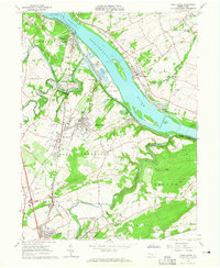
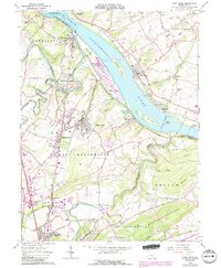
1964 Map of York Haven
USGS Topo · Published 1965About this map
Brunner Island and Haldeman Island dominate the Susquehanna River as it passes through the heart of this mid-1960s industrial and agricultural landscape. The river is a center of activity, from the powerplant and substation at Wago Junction to the turbulent waters of Conewago Falls and Haldeman Riffles. Inland, the boroughs of Mount Wolf and Manchester show significant residential development near the Pennsylvania Railroad line. Genealogists will find numerous family landmarks including Goods Cem, Haldeman Cem, and Brenneman Cem. The presence of the Codorus Furnace near the mouth of Codorus Creek points to the area's deep industrial roots, while the Hellam Hills and Schulls Rock define the eastern terrain above the river valley.
Find a feature on this map
72 named features on this map. Tap any name to fly to it.
Don’t see what you’re looking for? This feature index may not catch every label — zoom into the map to look around manually.
Map Details
Editions of this 1964 York Haven Map
5 editions found
Other maps of this area

1906 · New Cumberland
USGS Topo · 1:62,500

1908 · Middletown
USGS Topo · 1:62,500

1908 · York
USGS Topo · 1:62,500

1910 · York
USGS Topo · 1:62,500

1920 · Hanover
USGS Topo · 1:62,500

1922 · Hanover
USGS Topo · 1:62,500

1943 · New Cumberland
USGS Topo · 1:62,500

1943 · Middletown
USGS Topo · 1:62,500

1948 · Baltimore
USGS Topo · 1:250,000

1950 · Harrisburg
USGS Topo · 1:250,000