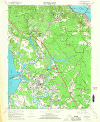
1965 Map of Yorktown
USGS Topo · Published 1968About this map
Yorktown and its deeply layered revolutionary landscape dominate this mid-century coastal survey. The terrain reflects centuries of military presence, from the preserved Battle Trenches and Surrender Ground within the Colonial National Historical Park to the sprawling modern footprint of the Fort Eustis Military Reservation and the U.S. Naval Weapons Station. Genealogists will find a wealth of specific local landmarks, including family-named sites like Cheesecake Cemetery and French Cemetery, as well as congregations at Rising Sun Church and Lebanon Church.
Find a feature on this map
85 named features on this map. Tap any name to fly to it.
Don’t see what you’re looking for? This feature index may not catch every label — zoom into the map to look around manually.
Map Details
Editions of this 1965 Yorktown Map
4 editions found
Other maps of this area

1906 · Williamsburg
USGS Topo · 1:62,500

1907 · Yorktown
USGS Topo · 1:62,500

1907 · Hampton
USGS Topo · 1:62,500

1916 · Mathews
USGS Topo · 1:62,500

1917 · Mathews
USGS Topo · 1:62,500

1943 · Yorktown
USGS Topo · 1:62,500

1943 · Richmond
USGS Topo · 1:250,000

1944 · Yorktown
USGS Topo · 1:24,000

1944 · Morrison
USGS Topo · 1:24,000

1944 · Harris Grove
USGS Topo · 1:24,000