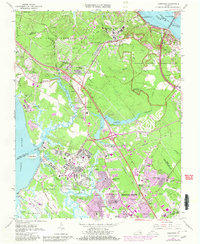
1965 Map of Yorktown
USGS Topo · Published 1980About this map
Colonial National Historical Park preserves the landscape of the Virginia Peninsula where the York and James Rivers nearly meet. This 1965 survey, updated with 1980 purple revisions, captures a region defined by its military significance and deep historical roots. The Surrender Ground and Yorktown National Cemetery mark the site of the 1781 siege, while the expansive Fort Eustis Military Reservation and U S Naval Weapons Station reflect the modern strategic importance of the Tidewater. The Chesapeake and Ohio Railroad cuts through the center, linking established settlements like Lee Hall and Lackey with the growing urban sprawl of Newport News. Reservoirs such as Skiffes Creek Reservoir and Beaverdam Reservoir dominate the interior, illustrating the industrial and municipal water needs of the mid-20th century. For genealogists and local historians, the inclusion of small community landmarks like Rising Sun Ch and Cheesecake Cem provides a detailed look at the rural fabric existing alongside major federal installations.
Find a feature on this map
95 named features on this map. Tap any name to fly to it.
Don’t see what you’re looking for? This feature index may not catch every label — zoom into the map to look around manually.
Map Details
Editions of this 1965 Yorktown Map
4 editions found
Other maps of this area

1906 · Williamsburg
USGS Topo · 1:62,500

1907 · Yorktown
USGS Topo · 1:62,500

1907 · Hampton
USGS Topo · 1:62,500

1916 · Mathews
USGS Topo · 1:62,500

1917 · Mathews
USGS Topo · 1:62,500

1943 · Yorktown
USGS Topo · 1:62,500

1943 · Richmond
USGS Topo · 1:250,000

1944 · Yorktown
USGS Topo · 1:24,000

1944 · Morrison
USGS Topo · 1:24,000

1944 · Harris Grove
USGS Topo · 1:24,000