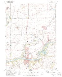
1993 Map of Yorkville
USGS Topo · Published 1994About this map
The Fox River carves a significant corridor through this portion of Kendall County, serving as the central geographic feature for the surrounding communities of Yorkville and Bristol. Along its banks, the Glen D Palmer State Game Farm and Saw-Wee-Kee Park indicate a landscape heavily dedicated to conservation and public recreation. The terrain of Rob Roy and the winding course of Blackberry Creek define the local topography, while numerous family and community burial grounds, including St Patricks Cem, Oak Grove Cem, and Jericho Cem, provide essential data points for local genealogists.
Find a feature on this map
52 named features on this map. Tap any name to fly to it.
Don’t see what you’re looking for? This feature index may not catch every label — zoom into the map to look around manually.
Map Details
Editions of this 1993 Yorkville Map
This is the sole edition of this map. No revisions or reprints were ever made.
Other maps of this area

1925 · Yorkville
USGS Topo · 1:62,500

1932 · Geneva
USGS Topo · 1:62,500

1937 · Sycamore
USGS Topo · 1:62,500

1948 · Geneva
USGS Topo · 1:62,500

1948 · Sandwich
USGS Topo · 1:62,500

1950 · Sandwich
USGS Topo · 1:62,500

1950 · Aurora North
USGS Topo · 1:24,000

1953 · Plattville
USGS Topo · 1:24,000

1953 · Yorkville
USGS Topo · 1:24,000

1953 · Yorkville SE
USGS Topo · 1:24,000