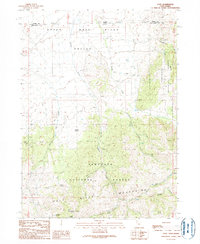
1990 Map of Yost
USGS Topo · Published 1990About this map
The small settlement of Yost sits at the foot of the Raft River Mountains, serving as a focal point in this high-altitude landscape where the Upper Raft River Valley meets the northern slopes of the range. Surveyed in the 1980s, the terrain is defined by the complex drainage systems of Johnson Creek and George Creek, which flow northward from the Sawtooth National Forest toward the Idaho border. The map captures a working landscape of resource extraction and seasonal water management, evidenced by numerous adits, prospects, and a gravel pit tucked into the foothills.
Find a feature on this map
29 named features on this map. Tap any name to fly to it.
Don’t see what you’re looking for? This feature index may not catch every label — zoom into the map to look around manually.
Map Details
Editions of this 1990 Yost Map
This is the sole edition of this map. No revisions or reprints were ever made.
Other maps of this area

1954 · Pocatello
USGS Topo · 1:250,000

1954 · Brigham City
USGS Topo · 1:250,000

1958 · Pocatello
USGS Topo · 1:250,000

1958 · Brigham City
USGS Topo · 1:250,000

1959 · Park Valley
USGS Topo · 1:62,500

1959 · Yost
USGS Topo · 1:62,500

1962 · Brigham City
USGS Topo · 1:250,000

1968 · Almo
USGS Topo · 1:24,000

1968 · Jim Sage Canyon
USGS Topo · 1:24,000

1968 · Chokecherry Canyon
USGS Topo · 1:24,000