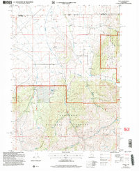
2001 Map of Yost
USGS Topo · Published 2006About this map
The Upper Raft River Valley sits at the high-desert intersection of the Idaho and Utah border, where the Sawtooth National Forest meets the northern slopes of the Ra River Mountains. This 2001 revision of the local topography captures a landscape defined by seasonal water and small-scale resource extraction. The community at Yost is documented here as a site, with the Yost Cem nearby serving as a primary landmark for genealogists and local historians.
Find a feature on this map
34 named features on this map. Tap any name to fly to it.
Don’t see what you’re looking for? This feature index may not catch every label — zoom into the map to look around manually.
Map Details
Editions of this 2001 Yost Map
This is the sole edition of this map. No revisions or reprints were ever made.
Other maps of this area

1954 · Pocatello
USGS Topo · 1:250,000

1954 · Brigham City
USGS Topo · 1:250,000

1958 · Pocatello
USGS Topo · 1:250,000

1958 · Brigham City
USGS Topo · 1:250,000

1959 · Park Valley
USGS Topo · 1:62,500

1959 · Yost
USGS Topo · 1:62,500

1962 · Brigham City
USGS Topo · 1:250,000

1968 · Almo
USGS Topo · 1:24,000

1968 · Jim Sage Canyon
USGS Topo · 1:24,000

1968 · Chokecherry Canyon
USGS Topo · 1:24,000