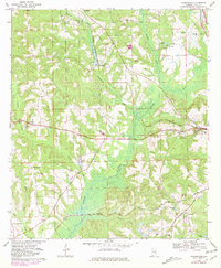
1968 Map of Youngblood
USGS Topo · Published 1981About this map
The Conecuh River meanders through this portion of Pike County, creating a landscape of wide bottomlands and winding tributaries like Beeman Creek and Double Branch. The rail infrastructure of the late twentieth century is prominent, featuring the Seaboard Coast Line running east-west and the Central of Georgia Road crossing through the southern portion of the map. Smaller communities and rural hubs such as Youngblood and Hephzibah are detailed alongside numerous religious and burial sites that serve as vital records for local genealogy. Notable landmarks include the Troy Municipal Airport and the Greene Hills Memorial Cem near the outskirts of Troy. The area shows a transition from the structured town environment to the riparian marshlands near Carters Pond and Whaleys Pond, illustrating the importance of water management and transport to the local economy.
Find a feature on this map
39 named features on this map. Tap any name to fly to it.
Don’t see what you’re looking for? This feature index may not catch every label — zoom into the map to look around manually.
Map Details
Editions of this 1968 Youngblood Map
2 editions found
Other maps of this area

1948 · Brundidge
USGS Topo · 1:62,500

1950 · Brundidge
USGS Topo · 1:62,500

1953 · Andalusia
USGS Topo · 1:250,000

1953 · Dothan
USGS Topo · 1:250,000

1954 · Dothan
USGS Topo · 1:250,000

1955 · Dothan
USGS Topo · 1:250,000

1957 · Andalusia
USGS Topo · 1:250,000

1960 · Brundidge NW
USGS Topo · 1:24,000
1962 · Brundidge NW
USGS Topo · 1:25,000
1968 · Goshen
USGS Topo · 1:24,000