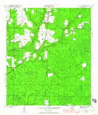
1945 Map of Youngstown
USGS Topo · Published 1960About this map
Youngstown serves as the primary hub of activity in this mid-1940s landscape, situated along the critical transit corridor of the Atlanta and St Andrews Bay RR. Small rural settlements like Nixon and Cairo are tied to this rail line, which cuts through a heavily wooded terrain dominated by extensive wetlands and seasonal drainages. The Bearthick Swamp and the Green Bay and Broad Branch Swamp cover significant portions of the eastern and southern reaches, while Bear Creek and its many tributaries, such as Beechwood Branch, form a complex hydrological network. Local life and connectivity are further evidenced by the Bear Creek Ch and the presence of the CCC Road and Scotts Ferry Road, highlighting the era's reliance on both improved rail infrastructure and early forest management routes to navigate the dense Florida Panhandle backcountry.
Find a feature on this map
22 named features on this map. Tap any name to fly to it.
Don’t see what you’re looking for? This feature index may not catch every label — zoom into the map to look around manually.
Map Details
Editions of this 1945 Youngstown Map
3 editions found
Other maps of this area

1944 · Bayhead
USGS Topo · 1:24,000

1944 · Bennett
USGS Topo · 1:24,000

1945 · Juniper Creek
USGS Topo · 1:31,680

1945 · Youngstown
USGS Topo · 1:31,680

1945 · Bennett
USGS Topo · 1:31,680

1945 · Bayhead
USGS Topo · 1:31,680

1945 · Broad Branch
USGS Topo · 1:31,680

1945 · North Of Allanton
USGS Topo · 1:31,680

1945 · Fountain
USGS Topo · 1:31,680

1945 · Tenmile Swamp
USGS Topo · 1:31,680