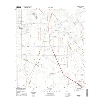
2015 Map of Youngsville
USGS Topo · Published 2015About this map
Youngsville and Broussard anchor this 2015 study of the Louisiana landscape where Lafayette, St. Martin, Iberia, and Vermilion Parishes converge. The map documents a complex drainage network vital to this low-lying region, including the winding Bayou Pare Perdu, LaSalle Coulee, and Coulee Malam. These natural waterways are supplemented by the Norris Branch Canal, illustrating the region's managed hydrology. Small aviation hubs like Sky Ranch Airport and Richard's Airport appear alongside older settlements such as Lozes, Duchamp, and Coteau. The residential expansion is evident in the dense network of roads like Sugar Trace Dr and Copperfield Way, showing the transition from agricultural tracts to modern suburban development while maintaining traditional parish boundaries.
Find a feature on this map
149 named features on this map. Tap any name to fly to it.
Don’t see what you’re looking for? This feature index may not catch every label — zoom into the map to look around manually.
Map Details
Editions of this 2015 Youngsville Map
This is the sole edition of this map. No revisions or reprints were ever made.
Other maps of this area

1932 · Abbeville NE
USGS Topo · 1:31,680

1937 · Derouen
USGS Topo · 1:62,500

1939 · St. Martinsville
USGS Topo · 1:62,500

1945 · New Orleans
USGS Topo · 1:250,000

1946 · Milton
USGS Topo · 1:31,680

1946 · Lafayette
USGS Topo · 1:31,680

1952 · Lake Charles
USGS Topo · 1:250,000

1954 · Lafayette
USGS Topo · 1:31,680
1954 · Milton
USGS Topo · 1:31,680

1954 · Port Arthur
USGS Topo · 1:250,000