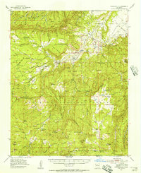
1953 Map of Youngsville
USGS Topo · Published 1956About this map
Youngsville serves as a primary settlement within this high-elevation landscape, where the Santa Fe National Forest meets sprawling land grants like the Piedra Lumbre Grant. This mid-century survey reveals a rural economy centered on timber and ranching, evidenced by the Mascareñas Sawmill and the Upper Coyote Creek Sawmill (Abandoned). Local life is anchored by family-named cabins and community landmarks, including the Santa Teresa Church and remote education centers such as the Mesa Poleo School and Mesa Pinabetal School.
Find a feature on this map
70 named features on this map. Tap any name to fly to it.
Don’t see what you’re looking for? This feature index may not catch every label — zoom into the map to look around manually.
Map Details
Editions of this 1953 Youngsville Map
2 editions found
Other maps of this area

1890 · Jemes
USGS Topo · 1:125,000

1892 · Jemes
USGS Topo · 1:125,000

1892 · Santa Clara
USGS Topo · 1:125,000

1909 · Gallina
USGS Topo · 1:125,000

1918 · Abiquiu
USGS Topo · 1:125,000

1937 · Jemez Springs
USGS Topo · 1:48,000

1939 · La Ventana
USGS Topo · 1:62,500

1940 · Cuba
USGS Topo · 1:62,500

1943 · Cuba
USGS Topo · 1:62,500

1943 · La Ventana
USGS Topo · 1:62,500