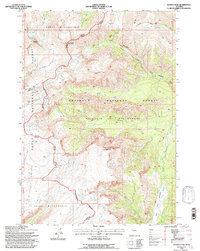
1991 Map of Younts Peak
USGS Topo · Published 1997About this map
Younts Peak rises as a primary landmark in this 1991 revision of high-altitude wilderness along the Continental Divide. The landscape is defined by the headwaters of major drainage systems, where the North Fork Yellowstone River and South Fork Yellowstone River begin their descent. This map reveals the administrative intersection of the Teton Wilderness, Shoshone National Forest, and Washakie Wilderness, showcasing a terrain managed for preservation rather than settlement. The presence of the Buffalo Wapiti Ranger District indicates the long-standing infrastructure of the Forest Service in this remote backcountry. Prominent peaks like Thorofare Mountain and Wall Mountain flank deep glacial valleys carved by Thorofare Creek and Marston Creek, while the Buffalo Plateau provides a high, level expanse south of Marston Pass.
Find a feature on this map
22 named features on this map. Tap any name to fly to it.
Don’t see what you’re looking for? This feature index may not catch every label — zoom into the map to look around manually.
Map Details
Editions of this 1991 Younts Peak Map
2 editions found
Other maps of this area

1893 · Ishawooa
USGS Topo · 1:125,000

1895 · Ishawooa
USGS Topo · 1:125,000

1899 · Ishawooa
USGS Topo · 1:125,000

1905 · Younts Peak
USGS Topo · 1:125,000

1907 · Younts Peak
USGS Topo · 1:125,000

1955 · Cody
USGS Topo · 1:250,000

1955 · Thermopolis
USGS Topo · 1:250,000

1956 · Shoshone Pass
USGS Topo · 1:24,000

1956 · Five Pockets
USGS Topo · 1:24,000
1956 · Dundee Meadows
USGS Topo · 1:24,000