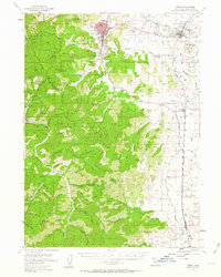
1954 Map of Yreka
USGS Topo · Published 1962About this map
Gold mining history and the reach of the Southern Pacific railroad define this section of Siskiyou County in the mid-1950s. The landscape is dominated by the steep ridges of the Klamath National Forest, where named claims like Humbug Mine, Mt Vernon Mine, and Scorpion Mine mark the persistent search for mineral wealth. The settlement of Yreka serves as the regional hub, complete with its County Fairgrounds, Municipal Airport, and local media outlets like Radio Tower KSYC.
Find a feature on this map
83 named features on this map. Tap any name to fly to it.
Don’t see what you’re looking for? This feature index may not catch every label — zoom into the map to look around manually.
Map Details
Editions of this 1954 Yreka Map
3 editions found

Other maps of this area

1886 · Shasta
USGS Topo · 1:250,000

1894 · Shasta
USGS Topo · 1:250,000

1921 · Shasta Valley Sheet No 7
USGS Topo · 1:24,000

1921 · Shasta Valley Sheet No 1
USGS Topo · 1:24,000

1921 · Shasta Valley Sheet No 6
USGS Topo · 1:24,000

1921 · Shasta Valley Sheet No 2
USGS Topo · 1:24,000

1922 · Shasta Valley Sheet No 4
USGS Topo · 1:24,000

1922 · Shasta Valley Sheet No 1 S
USGS Topo · 1:24,000

1922 · Shasta Valley Sheet No 3
USGS Topo · 1:24,000

1922 · Shasta Valley Sheet No 3 S
USGS Topo · 1:24,000