
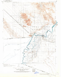
1903 Map of Yuma
USGS Topo · Published 1954About this map
The Colorado River defines this landscape where the borders of California, Arizona, and Mexico converge. Around the turn of the century, the region was characterized by burgeoning irrigation projects and remote mining outposts. The Yuma Indian Reservation dominates the center of the sheet, while the town of Yuma serves as a critical rail hub for the Southern Pacific RR. Significant waterworks, including the Imperial Canal and American Slough, illustrate early efforts to reclaim the desert for agriculture near Somerton. To the north, the terrain transitions into the Chocolate Mountains, where the Picacho Mine and American Mine represent the area's early 20th-century gold and mineral extraction. Rail travelers of the era would have passed through now-quiet sidings like Ogilby and Cactus while crossing the eastern edge of the Sand Hills.
Find a feature on this map
44 named features on this map. Tap any name to fly to it.
Don’t see what you’re looking for? This feature index may not catch every label — zoom into the map to look around manually.
Map Details
Editions of this 1903 Yuma Map
2 editions found
Other maps of this area

1905 · Yuma
USGS Topo · 1:125,000

1907 · Holtville
USGS Topo · 1:125,000

1926 · Fortuna
USGS Topo · 1:62,500

1929 · Fortuna
USGS Topo · 1:62,500

1929 · Laguna
USGS Topo · 1:62,500

1939 · Red Hill
USGS Topo · 1:62,500

1940 · Yuma
USGS Topo · 1:62,500

1942 · El Centro
USGS Topo · 1:250,000

1942 · Yuma
USGS Topo · 1:250,000

1942 · Blythe
USGS Topo · 1:250,000