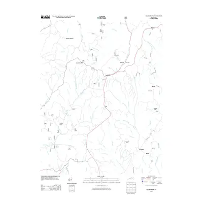
2013 Map of Zachariah
USGS Topo · Published 2013About this map
Standing Rock and Leeco anchor this 2013 topographies of Wolfe County, where the dendritic drainage patterns of the Cumberland Plateau create a landscape of narrow ridges and deep hollows. The rural character of the region is defined by scattered settlements and family landmarks, including Townsend Cem near Little Bend Ridge and Whisman Cem south of Rogers. This survey records a network of winding roads that follow the high ground, such as Shumaker Ridge Rd and Tolsen Rd, connecting isolated communities like Fixer and Zoe.
Find a feature on this map
72 named features on this map. Tap any name to fly to it.
Don’t see what you’re looking for? This feature index may not catch every label — zoom into the map to look around manually.
Map Details
Editions of this 2013 Zachariah Map
This is the sole edition of this map. No revisions or reprints were ever made.
Other maps of this area

1892 · Beattyville
USGS Topo · 1:125,000

1951 · Pomeroyton
USGS Topo · 1:24,000

1952 · Stanton
USGS Topo · 1:24,000

1952 · Slade
USGS Topo · 1:24,000

1952 · Tallega
USGS Topo · 1:24,000

1952 · Beattyville
USGS Topo · 1:24,000

1952 · Cobhill
USGS Topo · 1:24,000
1952 · Campton
USGS Topo · 1:24,000

1952 · Heidelberg
USGS Topo · 1:24,000

1953 · Zachariah
USGS Topo · 1:24,000