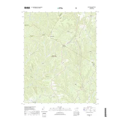
2019 Map of Zachariah
USGS Topo · Published 2019About this map
Daniel Boone National Forest encompasses the deeply dissected plateau where Zachariah and Leeco sit along the winding ridges of Wolfe and Lee counties. This 2019 survey documents a landscape defined by sharp elevation changes and a complex network of waterways, including Hell for Certain Cr and the Middle Fork Red River. The settlement patterns here are strictly tied to the high ground, with communities like Standing Rock and Zoe following the narrow corridors of modern roads that trace the ancient topography of Big Bend Ridge and Shumaker Ridge. Genealogists will find a wealth of family-named landmarks and resting places, such as the Thacker Cem, Whisman Cem, and Hopewell Church Cem. The map also captures the path of the Sheltowee Trace NRT, marking this as a modern record of both human habitation and recreational wilderness in the Kentucky hills.
Find a feature on this map
78 named features on this map. Tap any name to fly to it.
Don’t see what you’re looking for? This feature index may not catch every label — zoom into the map to look around manually.
Map Details
Editions of this 2019 Zachariah Map
This is the sole edition of this map. No revisions or reprints were ever made.
Other maps of this area

1892 · Beattyville
USGS Topo · 1:125,000

1951 · Pomeroyton
USGS Topo · 1:24,000

1952 · Stanton
USGS Topo · 1:24,000

1952 · Slade
USGS Topo · 1:24,000

1952 · Tallega
USGS Topo · 1:24,000

1952 · Beattyville
USGS Topo · 1:24,000

1952 · Cobhill
USGS Topo · 1:24,000
1952 · Campton
USGS Topo · 1:24,000

1952 · Heidelberg
USGS Topo · 1:24,000

1953 · Zachariah
USGS Topo · 1:24,000