
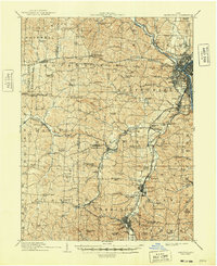
1910 Map of Zanesville
USGS Topo · Published 1939About this map
Zanesville stands as the industrial and transportation hub of Muskingum County in this early twentieth-century survey, where the Licking River joins the Muskingum River. The city’s dense street grid gives way to a complex network of railroads, including the Zanesville and Western Ry and the Cincinnati and Muskingum Valley RR, which follow the river valleys and serve the clay-rich industrial corridor to the south. Along the southern rail lines, the settlements of Roseville and Crooksville highlight the region's importance in stoneware and pottery manufacturing.
Find a feature on this map
83 named features on this map. Tap any name to fly to it.
Don’t see what you’re looking for? This feature index may not catch every label — zoom into the map to look around manually.
Map Details
Editions of this 1910 Zanesville Map
2 editions found
Other maps of this area

1907 · Logan
USGS Topo · 1:62,500

1908 · Conesville
USGS Topo · 1:62,500

1909 · Newark
USGS Topo · 1:62,500

1909 · Thornville
USGS Topo · 1:62,500

1909 · Logan
USGS Topo · 1:62,500

1910 · Frazeysburg
USGS Topo · 1:62,500

1910 · Philo
USGS Topo · 1:62,500

1910 · Conesville
USGS Topo · 1:62,500

1910 · Mc Connelsville
USGS Topo · 1:62,500

1911 · New Lexington
USGS Topo · 1:62,500