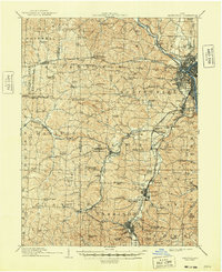
1910 Map of Zanesville
USGS Topo · Published 1948About this map
The Licking River and Muskingum River converge at Zanesville, a significant industrial and transportation hub in the early twentieth century. This survey reveals a landscape defined by its deep connectivity, where the historic National Road and Maysville Pike intersect with a dense network of steam and electric transit. The Ohio Electric Ry and Cincinnati and Muskingum Valley RR trace the river valleys, serving established communities like Putnam and South Zanesville.
Find a feature on this map
114 named features on this map. Tap any name to fly to it.
Don’t see what you’re looking for? This feature index may not catch every label — zoom into the map to look around manually.
Map Details
Editions of this 1910 Zanesville Map
2 editions found
Other maps of this area

1907 · Logan
USGS Topo · 1:62,500

1908 · Conesville
USGS Topo · 1:62,500

1909 · Newark
USGS Topo · 1:62,500

1909 · Thornville
USGS Topo · 1:62,500

1909 · Logan
USGS Topo · 1:62,500

1910 · Frazeysburg
USGS Topo · 1:62,500

1910 · Philo
USGS Topo · 1:62,500

1910 · Zanesville
USGS Topo · 1:62,500

1910 · Conesville
USGS Topo · 1:62,500

1910 · Mc Connelsville
USGS Topo · 1:62,500