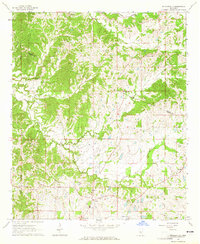
1964 Map of Zeiglerville
USGS Topo · Published 1965About this map
Hill country rural life across the Holmes and Yazoo County line is documented in this 1960s survey, showing a landscape defined by small-scale agriculture and church-centered communities. Small settlements like Zeiglerville and Pierce Crossroad serve as anchors in an area deeply carved by the headwaters of Tesheva Creek and Harland Creek. The map reveals a high density of country churches, such as Crossroads Ch, Antioch Ch, and St Luke Ch, many with adjacent cemeteries like the Riley Cem. These sites, along with the King Sch, provide essential touchpoints for genealogists tracing family footprints in the Mississippi interior. Scattered Gravel Pits suggest the local extraction industries that operated alongside the farms, while the winding road network connects more isolated locales like Fordyke and Midway to the larger crossings.
Find a feature on this map
24 named features on this map. Tap any name to fly to it.
Don’t see what you’re looking for? This feature index may not catch every label — zoom into the map to look around manually.
Map Details
Editions of this 1964 Zeiglerville Map
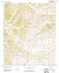
2 editions found
Other maps of this area

1940 · Lexington
USGS Topo · 1:62,500

1940 · Mileston
USGS Topo · 1:62,500

1953 · Greenwood
USGS Topo · 1:250,000

1954 · Mileston
USGS Topo · 1:62,500

1955 · Jackson
USGS Topo · 1:250,000

1956 · Greenwood
USGS Topo · 1:250,000

1957 · Lexington
USGS Topo · 1:62,500

1958 · Lexington
USGS Topo · 1:62,500

1961 · Jackson
USGS Topo · 1:250,000

1961 · Valley
USGS Topo · 1:62,500