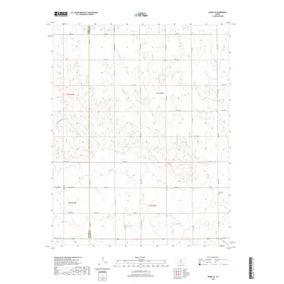
2018 Map of Zenda SE
USGS Topo · Published 2018About this map
Cottonwood Cr and W Sandy Cr carve a network of drainage patterns across this rural landscape along the eastern edge of Barber County. The terrain is defined by the headwaters and tributaries of several local streams, including Bachelor Cr and W Br Bluff Cr, which create a complex topography of ridges and draws. This 2018 survey illustrates the persistent section-line road grid that organizes the Kansas prairie, with routes like Thistle Rd and Blackmare Rd navigating the contours of the land. For genealogists and local historians, the Baird Cem serves as a primary point of interest, representing a enduring landmark in a region characterized by dispersed farmsteads and agricultural use. The boundary between Barber Co and Harper Co runs vertically through the western portion of the map, marking a significant political and historical divide in the south-central Kansas countryside.
Find a feature on this map
26 named features on this map. Tap any name to fly to it.
Don’t see what you’re looking for? This feature index may not catch every label — zoom into the map to look around manually.
Map Details
Editions of this 2018 Zenda SE Map
This is the sole edition of this map. No revisions or reprints were ever made.
Other maps of this area

1889 · Anthony
USGS Topo · 1:125,000

1891 · Anthony
USGS Topo · 1:125,000

1955 · Pratt
USGS Topo · 1:250,000

1959 · Pratt
USGS Topo · 1:250,000

1972 · Attica
USGS Topo · 1:24,000

1972 · Sharon South
USGS Topo · 1:24,000

1972 · Crisfield
USGS Topo · 1:24,000
1973 · Spivey
USGS Topo · 1:24,000
1973 · Crystal Springs
USGS Topo · 1:24,000
1973 · Sharon North
USGS Topo · 1:24,000