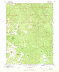
1967 Map of Zenia
USGS Topo · Published 1969About this map
Six Rivers National Forest dominates this Trinity County terrain, where mid-century life followed the contours of high ridges and deep river valleys. The settlement of Zenia serves as a primary reference point near the Hoaglin-Zenia Sch, while the remote southern valley centers on Kettenpom and the Kettenpom Valley. A network of pack trails and jeep trails crisscrosses the landscape, linking outposts like the Zenia Guard Station and the Kettenpom Lookout Tower perched on Kettenpom Peak. Evidence of the local ranching and rural economy is found at Shannon Ranch and the Clover School, illustrating the spread of small communities throughout these highlands before the era of modern highway access. The mapping of Robbers Roost and the numerous springs and gulches, such as Line Gulch, highlights the importance of water sources and strategic high ground in this section of the North Fk Eel R drainage.
Find a feature on this map
50 named features on this map. Tap any name to fly to it.
Don’t see what you’re looking for? This feature index may not catch every label — zoom into the map to look around manually.
Map Details
Editions of this 1967 Zenia Map
2 editions found

Other maps of this area

1918 · Anada
USGS Topo · 1:62,500

1920 · Harris
USGS Topo · 1:62,500

1921 · Hoaglin
USGS Topo · 1:62,500

1922 · Island Mountain
USGS Topo · 1:62,500

1931 · Hoaglin
USGS Topo · 1:96,000

1935 · Hoaglin
USGS Topo · 1:125,000

1949 · Blocksburg
USGS Topo · 1:62,500

1949 · Alderpoint
USGS Topo · 1:62,500

1951 · Alderpoint
USGS Topo · 1:62,500

1951 · Blocksburg
USGS Topo · 1:62,500