
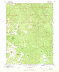
1967 Map of Zenia
USGS Topo · Published 1969About this map
Kettenpom Valley serves as a notable geographic focal point in this remote portion of Six Rivers National Forest, where the transition from high ridgelines to fertile depressions shaped early Trinity County settlement. The map traces the essential infrastructure of these isolated communities during the late 1960s, featuring landmarks like the Kettenpom Lookout Tower and the Zenia Guard Station. Educational and social life is anchored by the Hoaglin-Zenia Sch and Clover School, while the presence of the Shannon Ranch and several camps like Bear Wallow Camp suggests a landscape defined by timber, ranching, and seasonal forestry work. The terrain is deeply incised by the North Fork Eel River and its tributaries, including Panther Creek and Wilson Creek, with specialized transport indicated by a network of Pack Trails and a designated Landing Strip near Kettenpom.
Find a feature on this map
39 named features on this map. Tap any name to fly to it.
Don’t see what you’re looking for? This feature index may not catch every label — zoom into the map to look around manually.
Map Details
Editions of this 1967 Zenia Map
2 editions found
Other maps of this area

1918 · Anada
USGS Topo · 1:62,500

1920 · Harris
USGS Topo · 1:62,500

1921 · Hoaglin
USGS Topo · 1:62,500

1922 · Island Mountain
USGS Topo · 1:62,500

1931 · Hoaglin
USGS Topo · 1:96,000

1935 · Hoaglin
USGS Topo · 1:125,000

1949 · Blocksburg
USGS Topo · 1:62,500

1949 · Alderpoint
USGS Topo · 1:62,500

1951 · Alderpoint
USGS Topo · 1:62,500

1951 · Blocksburg
USGS Topo · 1:62,500