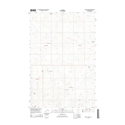
2014 Map of Ziegele Coulee
USGS Topo · Published 2014About this map
Southerland Coulee and Ziegele Coulee define the drainage patterns of this Garfield County landscape, where water has carved deep, winding channels through the high plains. This 2014 survey captures a section of Montana characterized by its complex hydrography, featuring numerous family-named landmarks like McClay Coulee, Graham Coulee, and Willis Coulee. The terrain is divided into distinct sections by the Public Land Survey System, including t17n r36e and t16n r37e. The few man-made alterations to the natural environment include Acosta Rd and a handful of other local connectors that cross the drainage of Sand Cr and Long Br. For those studying the geographic history of the region, this map provides the precise locations of these coulees as they appeared in the early 21st century, illustrating the enduring relationship between the topography and the drainage basins that shape this part of the state.
Find a feature on this map
13 named features on this map. Tap any name to fly to it.
Don’t see what you’re looking for? This feature index may not catch every label — zoom into the map to look around manually.
Map Details
Editions of this 2014 Ziegele Coulee Map
This is the sole edition of this map. No revisions or reprints were ever made.
Other maps of this area

1954 · Jordan
USGS Topo · 1:250,000

1956 · Jordan
USGS Topo · 1:250,000

1958 · Jordan
USGS Topo · 1:250,000

1964 · Jordan
USGS Topo · 1:250,000

1964 · Jordan
USGS Topo · 1:24,000

1965 · Big Dry School
USGS Topo · 1:24,000

1965 · Darby Buttes
USGS Topo · 1:24,000

1965 · Ziegele Coulee
USGS Topo · 1:24,000
1965 · Darby Buttes SW
USGS Topo · 1:24,000
1965 · Fig Mountain
USGS Topo · 1:24,000