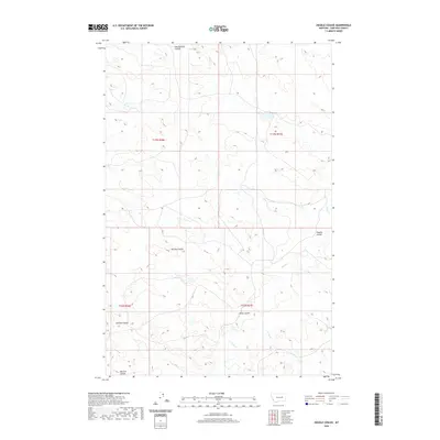
2020 Map of Ziegele Coulee
USGS Topo · Published 2020About this map
Ziegele Coulee and its neighboring drainage systems define this section of Garfield County, Montana. This high-plains landscape is intricately carved by intermittent watercourses like Southerland Coulee in the north and Harston Coulee to the southwest. The terrain patterns on this sheet reveal the erosive force of the seasonal hydrology that feeds into larger arteries such as Sand Cr and the winding Long Br. These features reflect the complex topography of a region dominated by coulees—deep, often dry ravines or gulches—that serve as the primary landmarks for navigation and land division. The map provides a detailed view of the sectional grid lines that overlay this geography, showing how local landmarks like McClay Coulee and Willis Coulee intersect with the boundaries of Township 16 and 17 North.
Find a feature on this map
18 named features on this map. Tap any name to fly to it.
Don’t see what you’re looking for? This feature index may not catch every label — zoom into the map to look around manually.
Map Details
Editions of this 2020 Ziegele Coulee Map
This is the sole edition of this map. No revisions or reprints were ever made.
Other maps of this area

1954 · Jordan
USGS Topo · 1:250,000

1956 · Jordan
USGS Topo · 1:250,000

1958 · Jordan
USGS Topo · 1:250,000

1964 · Jordan
USGS Topo · 1:250,000

1964 · Jordan
USGS Topo · 1:24,000

1965 · Big Dry School
USGS Topo · 1:24,000

1965 · Darby Buttes
USGS Topo · 1:24,000

1965 · Ziegele Coulee
USGS Topo · 1:24,000
1965 · Darby Buttes SW
USGS Topo · 1:24,000
1965 · Fig Mountain
USGS Topo · 1:24,000