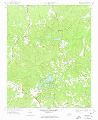
1977 Map of Zion Grove
USGS Topo · Published 1978About this map
Zion Grove and the surrounding Moore County landscape in the late 1970s reveal a transition from traditional rural settlements to more modern recreational and residential developments. The emerging Seven Lakes area, characterized by its numerous small water bodies, stands in contrast to established crossroads and communities such as Adolphus, Eagle Springs, and Thomas Crossroads. The southern portion of the quadrangle is defined by the Norfolk Southern railway line, which historically linked these agrarian communities to wider markets.
Find a feature on this map
35 named features on this map. Tap any name to fly to it.
Don’t see what you’re looking for? This feature index may not catch every label — zoom into the map to look around manually.
Map Details
Editions of this 1977 Zion Grove Map
2 editions found
Other maps of this area

1942 · Troy
USGS Topo · 1:125,000

1948 · Southern Pines
USGS Topo · 1:62,500

1949 · West End
USGS Topo · 1:24,000

1949 · Jackson Springs
USGS Topo · 1:62,500

1950 · Southern Pines
USGS Topo · 1:24,000

1950 · Norman
USGS Topo · 1:24,000

1953 · Raleigh
USGS Topo · 1:250,000

1954 · Raleigh
USGS Topo · 1:250,000

1957 · Southern Pines
USGS Topo · 1:62,500
1957 · Southern Pines
USGS Topo · 1:24,000