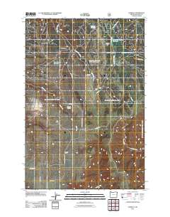
2011 Map of Zumwalt
USGS Topo · Published 2011About this map
Zumwalt and its namesake Zumwalt School anchor this portion of Wallowa County, situated within a high prairie landscape defined by ranching and water management. The area is marked by several notable homesteads and working outposts, including Steen Ranch, Gill Ranch, and the Chesnimnus Cow Camp. The importance of water in this high-altitude environment is evident in the numerous impoundments scattered across the terrain, such as Berland Reservoir, Davis Spring Reservoir, and Thomason Meadow Reservoir.
Find a feature on this map
30 named features on this map. Tap any name to fly to it.
Don’t see what you’re looking for? This feature index may not catch every label — zoom into the map to look around manually.
Map Details
Editions of this 2011 Zumwalt Map
This is the sole edition of this map. No revisions or reprints were ever made.
Other maps of this area

1954 · Imnaha
USGS Topo · 1:62,500

1955 · Grangeville
USGS Topo · 1:250,000

1957 · Elk Mountain
USGS Topo · 1:62,500

1959 · Grangeville
USGS Topo · 1:250,000

1963 · Deadhorse Ridge
USGS Topo · 1:24,000

1963 · Poison Point
USGS Topo · 1:24,000
1967 · Billy Meadows
USGS Topo · 1:24,000

1980 · Grangeville
USGS Topo · 1:100,000

1982 · Wallowa
USGS Topo · 1:100,000

1990 · Imnaha
USGS Topo · 1:24,000