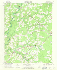
1969 Map of Zuni
USGS Topo · Published 1971About this map
The Blackwater River defines the western edge of this coastal plain landscape, winding through a network of wetlands and tributaries. The Norfolk and Western Railway cuts diagonally across the terrain, serving as a primary corridor connecting the settlements of Zuni, Dwight, and Windsor. This infrastructure supported a rural economy deeply integrated with the surrounding swamp system, including Antioch Swamp and Burnt Mills Swamp, which dictated the layout of local roads and farmsteads.
Find a feature on this map
43 named features on this map. Tap any name to fly to it.
Don’t see what you’re looking for? This feature index may not catch every label — zoom into the map to look around manually.
Map Details
Editions of this 1969 Zuni Map
Other maps of this area

1919 · Smithfield
USGS Topo · 1:62,500

1919 · Suffolk
USGS Topo · 1:62,500

1920 · Holland
USGS Topo · 1:62,500

1920 · Ivor
USGS Topo · 1:62,500

1943 · Holland
USGS Topo · 1:62,500

1944 · Windsor
USGS Topo · 1:31,680

1944 · Ivor
USGS Topo · 1:24,000

1944 · Smithfield
USGS Topo · 1:24,000

1944 · Sedley
USGS Topo · 1:24,000

1944 · Raynor
USGS Topo · 1:24,000