1990s Maps of Haines, Alaska
Explore 17 historic maps of Haines from the 1990s. These maps offer a rare glimpse into what life looked like during the 1990s — showing old roads, neighborhoods, homes, and landmarks that have changed or disappeared over time.
Whether you're researching your family's past, planning a metal detecting trip, or studying how Haines's landscape evolved across the 1990s, these high-resolution maps are a powerful tool for exploring the history of this region.
- Focus on a specific era: All maps on this page are from the 1990s, giving you a focused view of this time period.
- See what’s changed: Compare century-old streets, trails, and buildings to today's modern landscape using overlays and satellite layers.
- Research with precision: Use these maps for genealogy, historical research, land use analysis, or educational projects.
- View, download, or print: Maps are fully viewable online in high resolution, and can be downloaded or printed for your own records.
Start exploring Haines's history through authentic maps from the 1990s. This is your window into the past.
Haines, AK maps
(17)- 1991 Map of Skagway B-3 SW
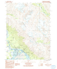
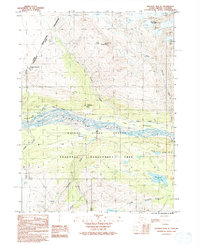
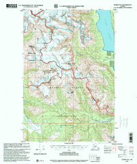
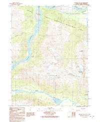 1991 Skagway B-3 SW1991 Print · USGSHaines, Alaska is documented here in the early 1990s, where the great river systems meet the coastal mountains. Researchers can trace the Dalton Trail and locate remote features like a wilderness Landing Strip and Chilkat Lake.
 - 1991 Map of Skagway B-3 NW
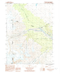
 1991 Skagway B-3 NW1991 Print · USGSThe northern reaches of the Alaska Panhandle are documented here during the early nineties at the junction of three major glacial rivers. Historians can trace the Dalton Trail alongside the Klehini River and locate the Mosquito Lake State Recreation Site.
 - 1991 Map of Skagway B-2 SW
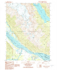 1991 Skagway B-2 SW1991 Print · USGSThis Southeast Alaska territory in the early nineties shows the convergence of the Takshanuuk Mountains and the braided Chilkat River. You can trace the historic Dalton Trail and the bounds of the Alaska Chilkat Bald Eagle Preserve (State).
 - 1991 Map of Skagway A-1 NW
 1991 Skagway A-1 NW1991 Print · USGSThe Chilkoot Peninsula and the mouth of the Katzehin River are captured here in the early nineties. Researchers can trace land division boundaries like U S Survey 1243 or follow Mud Bay Road toward the shores of Mud Bay.
 - 1991 Map of Skagway B-3 NE
 1991 Skagway B-3 NE1991 Print · USGSSoutheast Alaska in the early nineties reveals a landscape of massive glacial rivers and ancient settlements. Trace the junction of the Chilkat River and Klehini River to find the village of Klukwan, its local Cem, and the crossing at Wells Bridge.
 - 1991 Map of Skagway B-2 SE
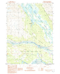
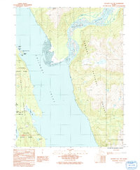
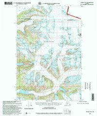
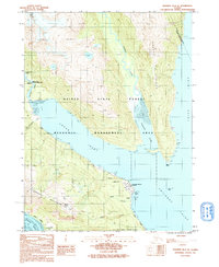 1991 Skagway B-2 SE1991 Print · USGSThe northern Alaskan coast near Haines comes into focus in the early nineties, showing a landscape defined by deep inlets and military infrastructure. Researchers can trace local landmarks like the Haines Fuel Terminal, the Ferry Dock, and the settlement at Tanani.
 - 1991 Map of Skagway B-3 SE
 1991 Skagway B-3 SE1991 Print · USGSThe Chilkat River valley in the early nineties is documented here as a landscape of protected habitats and historic transport routes. Researchers can trace the path of the Dalton Trail, locate the Klucktoo site, and see the extent of the Chilkat Lake shoreline.
 - 1991 Map of Skagway B-1 SW
 1991 Skagway B-1 SW1991 Print · USGSThe wilderness north of the Lynn Canal was captured in the early nineties as a landscape of ice and coastal inlets. Researchers can trace the glaciated terrain from Schubee Glacier down to the shores of Taiya Inlet and the Katzehin River.
 - 1991 Map of Skagway A-2 NE
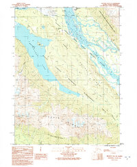
 1991 Skagway A-2 NE1991 Print · USGSCoastal Haines and the surrounding inlets are captured in the early nineties, showing a landscape defined by the sea and historical transit. Researchers can trace the Dalton Trail, locate Fort William H Seward, and study the old settlement of Yindastuki.
 - 1992 Map of Skagway B-4 NE
 1992 Skagway B-4 NE1992 Print · USGSThe international borderlands of Haines and British Columbia are shown here in the early 1990s as modern transit met historic routes. Researchers can trace the Dalton Trail (Historic-Indefinite) past Porcupine and along the Klehini River.
 - 1992 Map of Skagway B-4 NW
 1992 Skagway B-4 NW1992 Print · USGSThe Alaska-British Columbia borderlands near Haines are shown here in the early nineties, a period of managed wilderness and historic transit. Researchers can trace the Dalton (Historic Trail Indefinite) as it parallels the Klehini River and the site of Dalton Cache.
 - 1994 Map of Juneau A-5, 1998 Print
 1994 Juneau A-51998 Print · USGSCoastal Chichagof Island comes into focus in the 1990s, centering on the maritime hub of Hoonah and the surrounding wilderness. Researchers can trace the development of local infrastructure from the White Alice Comm Site to the Whitestone Logging Camp and Hoonah Harbor.
 - 1995 Map of Juneau A-4, 1999 Print
 1995 Juneau A-41999 Print · USGSSoutheast Alaska in the late twentieth century was a landscape of maritime navigation and timber harvesting near Point Couverden. Researchers can locate specialized sites like the Log Transfer Facility, the Vortac Station on The Sisters, and isolated Cabin Ruins.
 - 1996 Map of Juneau B-4, 2000 Print
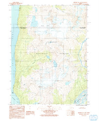
 1996 Juneau B-42000 Print · USGSCoastal wilderness and the heights of the Chilkat Range are documented in the late nineties as they border the City and Borough of Juneau. Trace the intersection of Glacier Bay National Park and the Tongass National Forest along Lynn Canal.
 - 1996 Map of Juneau C-4, 2000 Print
 1996 Juneau C-42000 Print · USGSThe Lynn Canal maritime corridor was a critical transit point in the late nineties, linking the Juneau and Haines boroughs by water. Researchers can trace remote coastal outposts like the Radio Repeater and navigate the protected reaches of St James Bay State Marine Park and the Lighthouse Reserve.
 - 1996 Map of Juneau D-5, 2000 Print
 1996 Juneau D-52000 Print · USGSThe Chilkat Range and coastal waters of Southeast Alaska are captured here in the late twentieth century. Researchers can trace the boundaries of the Endicott River Wilderness and locate remote landmarks like Mount Young and the Microwave Station.
 - 1997 Map of Juneau D-2, 2000 Print
 1997 Juneau D-22000 Print · USGSThe international boundary between Alaska and British Columbia near Juneau is shown here in the late 1990s as it cuts through the high peaks of the Coast Mountains. Trace the massive ice fields of Field Glacier and the steep terrain of The Wall.
End of results
Showing maps 1-17 of 17
Top cities of Haines
Frequently asked questions
- What are the different types of historical maps available for Haines?
- What is the oldest map of Haines?
- Where can I purchase historical maps of Haines for my home or office?
- Where can I download high-res historical maps of Haines?
- Are there historical topographic maps available for Haines?
- Is there historical aerial imagery available for Haines?
- Where are historical maps of Haines sourced from?