1950s Maps of Haines, Alaska
Explore 18 historic maps of Haines from the 1950s. These maps offer a rare glimpse into what life looked like during the 1950s — showing old roads, neighborhoods, homes, and landmarks that have changed or disappeared over time.
Whether you're researching your family's past, planning a metal detecting trip, or studying how Haines's landscape evolved across the 1950s, these high-resolution maps are a powerful tool for exploring the history of this region.
- Focus on a specific era: All maps on this page are from the 1950s, giving you a focused view of this time period.
- See what’s changed: Compare century-old streets, trails, and buildings to today's modern landscape using overlays and satellite layers.
- Research with precision: Use these maps for genealogy, historical research, land use analysis, or educational projects.
- View, download, or print: Maps are fully viewable online in high resolution, and can be downloaded or printed for your own records.
Start exploring Haines's history through authentic maps from the 1950s. This is your window into the past.
Haines, AK maps
(18)- 1950 Map of Juneau C-6, 1968 Print
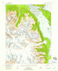
 1950 Juneau C-61968 Print · USGSCoastal Alaska at mid-century reveals a wilderness of glacial inlets and island chains within the Glacier Bay National Monument. Researchers can trace the complex shoreline of the Beardslee Islands and the courses of the Salmon River and Beartrack River.3 unique versions available
 - 1950 Map of Juneau B-5, 1968 Print
 1950 Juneau B-51968 Print · USGSSoutheast Alaska’s coastal wilderness comes into focus in the mid-twentieth century as maritime commerce and federal conservation intersect. Researchers can locate the Cannery at Excursion Inlet and trace heritage sites like the Indian Cem.2 unique versions available
 - 1951 Map of Juneau
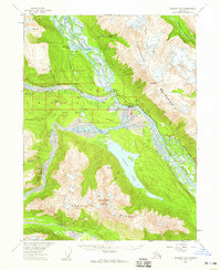
 1951 Juneau1951 Print · USGSJuneau and the industrial waterfront of the Gastineau Channel are shown here at the start of the 1950s. Researchers can trace the mid-century footprint of Juneau, the mining history of Treadwell, and remote maritime outposts like Hoonah and Gustavus.4 unique versions available
 - 1951 Map of Skagway A-1, 1952 Print
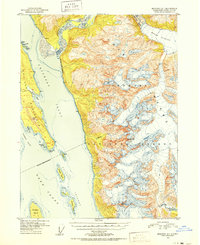 1951 Skagway A-11952 Print · USGSThe northern reaches of the Alaska Panhandle come into sharp focus in the early 1950s as a land of glaciers and deep-water inlets. Researchers can trace the maritime landscape from the Battery Point Light down to Sullivan Island and the mouth of the Katzehin River.2 unique versions available
 - 1951 Map of Atlin, 1952 Print
 1951 Atlin1952 Print · USGSThe international boundary between Alaska and British Columbia is charted here at the middle of the century, dominated by the Tongass National Forest. Researchers can trace the rugged border line across high peaks like Mt Poletica and the massive flow of Meade Glacier.
 - 1951 Map of Juneau D-4, 1952 Print
 1951 Juneau D-41952 Print · USGSSoutheast Alaska’s maritime and mining frontiers meet along Lynn Canal in the early fifties. Genealogists and industrial historians can trace the dormant gold works at Kensington Mine and the isolated Eldred Rock Lighthouse.2 unique versions available
 - 1951 Map of Juneau A-5, 1952 Print
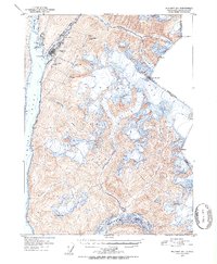
 1951 Juneau A-51952 Print · USGSThe Tlingit village of Hoonah and its surrounding coastal waters are captured here in the early fifties. Local historians can trace maritime life around Hoonah Harbor, from the waterfront Cannery to the inland Spasski Trail and old Cem sites.6 unique versions available
 - 1951 Map of Skagway B-1, 1952 Print
 1951 Skagway B-11952 Print · USGSSkagway and the head of Taiya Inlet are captured here in the early 1950s as a vital transportation hub. Trace the White Pass and Yukon Route and find local landmarks like Reid Falls, Lower Dewey Lake, and the town Powder House.2 unique versions available
 - 1951 Map of Skagway C-2, 1952 Print
 1951 Skagway C-21952 Print · USGSThe international boundary between Alaska and British Columbia is traced across massive ice fields in the early fifties. Researchers can study the extent of Chilkat Glacier and locate high-altitude landmarks like Mt Yeatman and the Ferebee Glacier.2 unique versions available
 - 1952 Map of Skagway, 1953 Print
 1952 Skagway1953 Print · USGSThe northern reaches of the Alaska Panhandle come alive in the early fifties, showing the vital rail and road links to the Yukon. Trace the historic White Pass & Yukon Route or locate remote camps like Pleasant Camp and Klukwan.4 unique versions available
 - 1953 Map of Juneau D-3, 1954 Print
 1953 Juneau D-31954 Print · USGSSoutheast Alaska in the early fifties shows a wild landscape of river deltas and mountain peaks within the Tongass National Forest. Researchers can locate a lone Cabin and trace the braided channels of the Lace River and Antler River as they enter Berners Bay.2 unique versions available
 - 1954 Map of Skagway B-2, 1959 Print
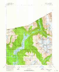
 1954 Skagway B-21959 Print · USGSThe Lynn Canal region of Alaska was a landscape of maritime navigation and glacial mountain passes in the mid-fifties. Genealogists and historians can trace the early footprint of the Yindastuki Indian Res and coastal sites like Tanani and Chilkoot.4 unique versions available
 - 1954 Map of Skagway A-3, 1959 Print
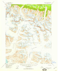 1954 Skagway A-31959 Print · USGSSoutheast Alaska in the mid-fifties is seen here as a wilderness of ice and peaks within Glacier Bay National Monument. Researchers can trace the mid-century extent of McBride Glacier, Casement Glacier, and the Takhin River.3 unique versions available
 - 1954 Map of Skagway A-2, 1959 Print
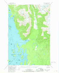
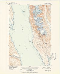
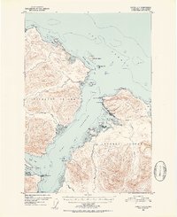
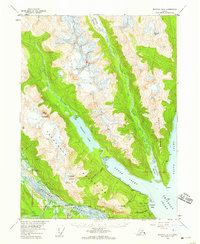
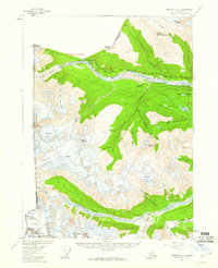
 1954 Skagway A-21959 Print · USGSSoutheast Alaska in the mid-fifties is defined here by the meeting of massive glaciers and maritime trade routes. Genealogists and historians can trace the early footprints of Haines and Port Chilkoot, locating a Cannery, Landing Field, and local homestead entries.3 unique versions available
 - 1954 Map of Skagway B-3, 1959 Print
 1954 Skagway B-31959 Print · USGSSoutheast Alaska in the mid-fifties reveals a landscape of glacial rivers and historic transit routes near the Canadian border. Genealogists and historians can trace the paths of the Indian Trail and Dalton Trail past the settlement of Klukwan and the cabins at Wells.2 unique versions available
 - 1954 Map of Skagway B-4, 1960 Print
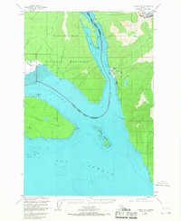
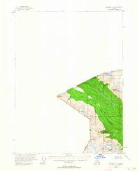
 1954 Skagway B-41960 Print · USGSThe international border and the mountain passes above Haines were being transformed by mid-century infrastructure as the highway and pipeline were established. Researchers can trace early settlements and natural landmarks from Pleasant Camp to the now Porcupine site near the Klehini River.2 unique versions available
 - 1954 Map of Skagway C-4, 1963 Print
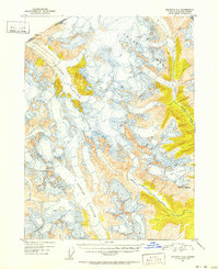
 1954 Skagway C-41963 Print · USGSThe high peaks of the international border were documented in the mid-1950s, capturing a remote landscape of glacial valleys and river systems. Researchers can trace the drainages of the Ketsatl River and Nataga Creek between summits like Mt Ashmun and Mt Seltat.
 - 1954 Map of Skagway C-3, 1964 Print
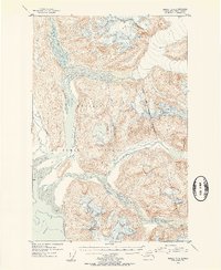
 1954 Skagway C-31964 Print · USGSThe Alaska-Canada borderlands in the mid-1950s appear here as a pristine network of glacial rivers and mountain peaks. Trace the braided channels of the Klehini River and Chilkat River or identify summits like Klukwah Mountain and Mt Raymond.
End of results
Showing maps 1-18 of 18
Top cities of Haines
Frequently asked questions
- What are the different types of historical maps available for Haines?
- What is the oldest map of Haines?
- Where can I purchase historical maps of Haines for my home or office?
- Where can I download high-res historical maps of Haines?
- Are there historical topographic maps available for Haines?
- Is there historical aerial imagery available for Haines?
- Where are historical maps of Haines sourced from?